

Dignitas Support for Common Driver Trainer
Posted on January 28th, 2020
.jpg)
Dignitas Support for Common Driver Trainer
Posted on January 28th, 2020
Dignitas Support for Common Driver Trainer
Posted on January 28th, 2020
Dignitas Support for Common Driver Trainer
Posted on January 28th, 2020

.png)

Megacities & Dense Urban Area Modeling
-
Simulating interactions between human and physical systems and leverage innovative sources of information and big data analytics.
-
Cerberus is a server-based application that provides current and future simulation systems the functionality to support underground environments.
-
PoL urban simulation (Vulgus) to include crowd and traffic modeling and effects.
-
Procedural generation of complex features and objects, including building interiors and underground features.
-
Conducting advanced geospatial research for U.S. Army Synthetic Training Environment (STE) OneWorld Terrain (OWT).
BENEFITS

High Resolution
Voxels and other advanced modeling techniques provide next generation solutions

Forward-Looking
Addressing tomorrow's simulation problems today

Dynamic
Represent complex environment effects in real-time
FEATURES

Megacities Testbed
We maintain an advanced research testbed to experiment with all aspects of Dense Urban Environment representations including complex geospatial data, underground environments, pattern of life (pedestrian and traffic), cyber civilian infrastructure and more.

Underground Environments
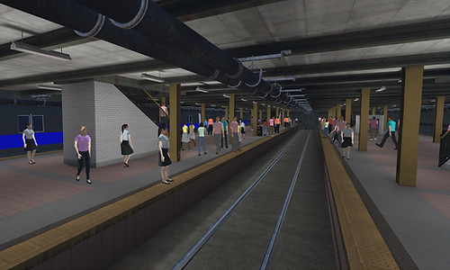
Our solutions consider aspects of the entire pipeline for underground representations, spanning from source data collection through to behaviors. Developing simulation engine-agnostic processes and algorithms to procedurally generate game-quality subway networks.
Using cutting-edge voxel technology for the representation of volumetric environments. Developing advanced Artificial Intelligence behaviors to navigate subterranean networks, including mounting subway trains.

Civilian Infrastructure
Current virtual and constructive simulation often neglect the civilian infrastructure and secondary effects. Our solutions represent suppliers and consumers representing items such as power, water supply, traffic signals, etc. This enables modeling of effects of supply disruption.

SNE as a Service (SNEaaS)
Provides a set of SNE services to support modeling, simulation, and training use cases.
Correlated and composable services discoverable and executable by SNE system of systems.

Machine Learning
Dignitas is using advanced Machine Learning techniques to enable automated discovery of complex geospatial features to derive data for areas where overhead and drive through sensors are ineffective, such as complex underground features. For example, we are using street level images (such as Google StreetMaps) to automatically detect manhole covers which can then be used to derive sewer line locations.
USE CASES

Terrain Reasoning
-
Advanced terrain reasoning algorithms to drive behavioral reasoning
-
Algorithms support dynamic effects and specialized use cases

Complex Representations
-
Representation of complex urban and underground effects
-
Specialized storage techniques such as voxels
Procedural Generation
-
Geotypical data where standard source data is not available
-
Machine learning applied to imagery supports derivation of realistic and geospecific data
GALLERY


MORE INFORMATION
PRODUCTS/SERVICES OFFERED
Our megacities testbed enables research into complex effects in dense urban environments, including physics-based damage effects (tunnel complex), representations in gaming environments such as Unreal or Unity, pedestrian traffic models, vehicle traffic models, lightweight virtual simulators, and more.